The continued unprecedented dry and hot conditions in British Columbia’s southern Interior has prompted government to increase the drought level in the Okanagan to 4. At drought level 4, licence holders who do not get their water from local water utilities are being asked to reduce water use by half. Water licence holders who get […]
News

by Mike Monaghan
Difficult to get a family of racc’s to pose GAZE OF RACCOONS or a Nursery The males are called boars and the females sows.

Down the aisle
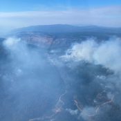
Nk’Mip Creek Fire – no indicated size of growth despite wind and heat
Location: 6 kilometres north of Osoyoos • See approximate location of this wildfire on an See Map interactive map • View an interactive map of all active Wildfires of Note. Discovered: Monday, July 19, 2021 Size: 17,472.0 hectares (estimated) Status: Active The fire is classified as Out of Control. Learn more about stages of control: […]
Covid Road map – 1st week of August
Latest figures for province and health authorities As of Thursday, Aug. 12, 2021, 82.3% (3,814,635) of eligible people 12 and older in B.C. have received their first dose of COVID-19 vaccine and 71.6% (3,318,751) received their second dose. In addition, 83.1% (3,596,148) of all eligible adults in B.C. have received their first dose and 73.3% […]

by Carmen Peone
Barnaby Island in Lake Roosevelt Roosevelt Lake between Grand Coulee Dam and Northport, Washington, in eastern Washington state. Nearest city is Spokane
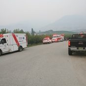
Quad flips just off Rd 8 – driver taken to hospital
6am Friday Superficial injuries No traffic impact RCMP to investigate EMS and Oliver Fire Department on scene
Hey Al – here we go again !
RE: Signage Regulations Purpose: The Regional District Board is seeking input from the Okanagan Valley Electoral Area Advisory Planning Commissions (APCs) regarding proposed revisions to the zoning regulations that govern the placement of commercial signage on a parcel. Background: Under Section 330 (Regulation of signs and advertising) of the Local Government Act, the Board “may, […]