At this stage in the season there is no elevated flood risk present in the current snowpack across the province. Normal seasonal flood risk is expected in the Peace, Upper Fraser and North Thompson. With below normal snowpack in most regions, reduced flood risk is expected. On the Fraser River, the overall basin index is 80% of normal; a peak flow in the range of 6500-8000 m3/s at Hope is likely with higher flows possible if adverse weather patterns, in particular heavy rainfall, emerge in the spring.
While snow is one significant aspect to seasonal flooding in BC, weather during the freshet season also plays a key role, and flooding is possible in years with near normal or lowsnowpack. In areas with low snowpack, key flood risks shift towards heavy precipitation events, either short-duration events or prolonged periods of wet weather. It is important to note that May and June are wet months through the BC Interior with the potential for extreme precipitation pattern.
In the Rockies and north-east BC, upper-low weather patterns can extend the flood season into July. Therefore, it is important to note that precipitation poses a real flood risk through the spring even with limited snowpack.
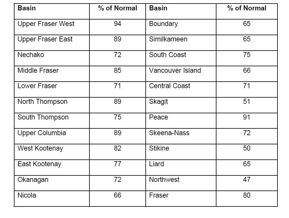
Snow basin indices for April 1st, 2019 range from a low of 47% of normal in the Northwest to a high of 94% in the Upper Fraser West with the average of all snow measurements across the province calculated to be 79% of normal.
A well-below normal snowpack (<60% of normal) is present in the Stikine, Northwest and Skagit. A below normal snowpack (60-80% of normal) exists in the Liard, Skeena-Nass, Nechako, Central Coast, South Coast, Lower Fraser, Vancouver Island, Similkameen, Nicola, Okanagan, South Thompson, Boundary and East Kootenay. The rest of the province has slightly below normal to normal snowpack (80-95% of normal). There are no regions in the province with normal or above normal snowpacks.