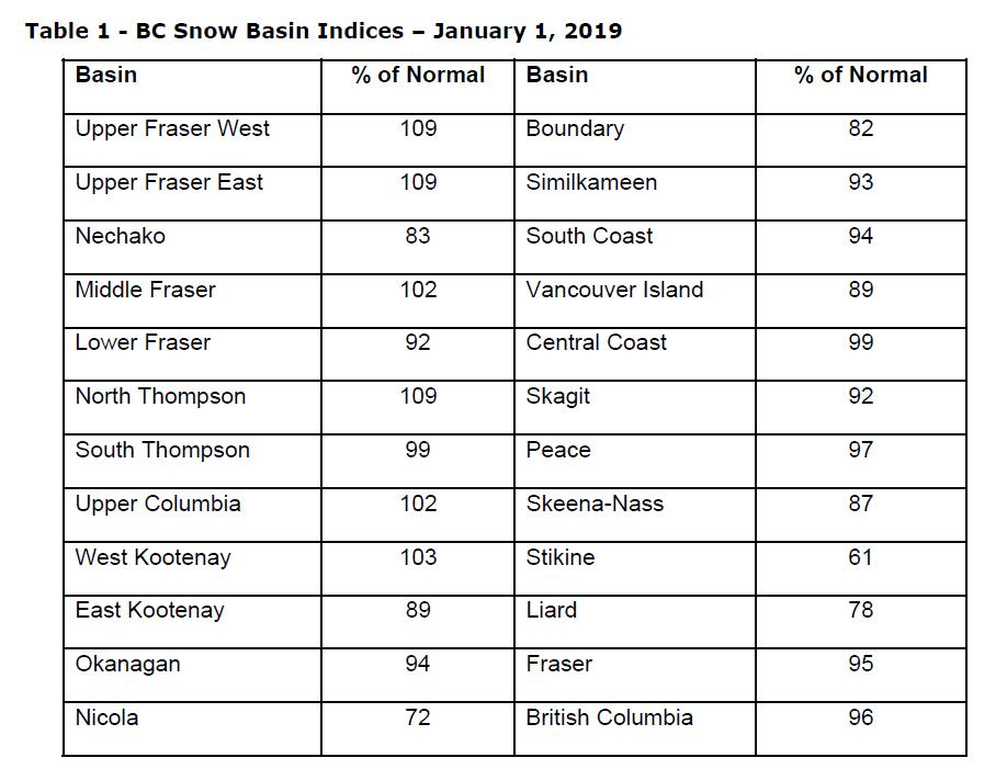
The January 1st snow survey is now complete. Data from 69 manual snow courses and 80 automated snow weather stations around the province (collected by the Ministry of
Environment Snow Survey Program, BC Hydro and partners), and climate data from Environment and Climate Change Canada and the provincial Climate Related Monitoring
Program have been used to form the basis of the following report1.
Weather
Fall and early winter weather had been variable across the province. October featured near normal (-0.5 to 0.5°C) temperatures across most of the province, with areas in south-west
BC reaching between 1 to 2°C above normal. Except for the Okanagan and South Interior, the province generally experienced below normal precipitation in October.
In early November, a series of storm events impacted south-west BC with heavy rain. The second half of the month featured more stable weather with less precipitation. Total
monthly precipitation was generally near normal across the province. Temperatures were generally above normal (+1 to +2°C) for southern BC, and well above normal (+1 to +5°C)
in central and northern BC.
A dramatic shift in weather patterns occurred in early/mid-December, bringing a series of Pacific storms. These caused significant precipitation across much of the province,
particularly south-west BC. Precipitation anomalies for December were in the 120-160% of normal range in southern BC, and closer to normal in other areas of the province.
Temperatures remained well above normal through December, with more modest temperature anomalies in south-west BC (+0.5 to +1.5°C) and more significant anomalies in the BC Interior (+2 to +5°C).
Outlook
The Climate Prediction Centre (CPC) at the U.S. National Weather Service/NOAA has issued an El Niño watch and is forecasting a high likelihood of El Niño developing through this
winter and continuing into the spring. Typically, El Niño is linked to warmer winters across British Columbia. During El Niño, snowpacks tend to be lower than normal; however, there
has been a large range of variability in snowpack in BC during El Niño winters in the past (for example 2007 was following an El Niño winter and had significant snowpack across the
province). Warm sea surface temperature anomalies have also persisted in the Pacific Ocean off the BC/Alaska coast, with a general weakening in the anomaly since mid-
November. Warm temperature anomalies in the Pacific often have a similar or enhancing effect when they occur in phase with El Niño, as was the case in 2014-15 and 2015-16.