Outlook
Flood risk from this season’s snow pack has now subsided, and river levels across the province have been receding. In many areas of the province, streamflow has transitioned from well above normal flows in April and May, towards below normal flow in early-June.
This is particularly the case on Vancouver Island, coastal BC, northern BC, southern BC and central BC.
While snow melt related flood risks may be diminished, on-going risks from extreme rainfall events continue to exist. From a climatological perspective, June is a month where extreme rainfall does occur in the BC Interior, and continued vigilance around these patterns is prudent for on-going flood response through the rest of this freshet season.
With the shift to earlier melt, snow melt influence on river systems around the province isexpected to wane early this year, bringing increased risk for low flows later this summer.
These risks include areas which started the freshet season with above normal snow pack.
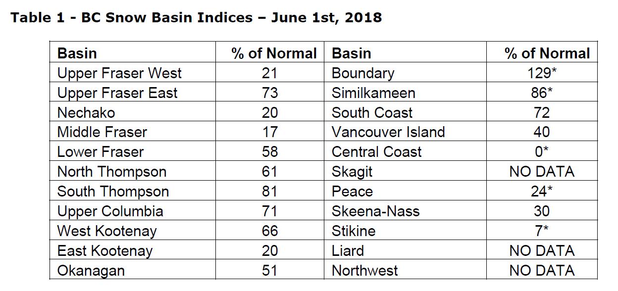
Areas with increased risk for summer low flows this year include the Skeena, Peace, Liard,
Upper Fraser West, Middle Fraser/Cariboo, central Coast, Vancouver Island, Okanagan,
Lower Fraser and East Kootenay.
While snow plays a role in summer low flows, late-spring and summer weather is ultimately the key driver of whether low flow conditions emerge later this summer or not. Current near-term weather forecasts are indicating that the trend away from the hot and dry
weather in May has shifted into cooler and wetter patterns through the middle of June.
Long-range seasonal weather forecasts from Environment and Climate Change Canada are indicating an increased likelihood of warmer than normal and drier than normal conditions across the June-July-August period. With early snow melt and the increased likelihood of adverse summer weather conditions, there are increased province-wide risks this year for low flow and drought.