Snowpack
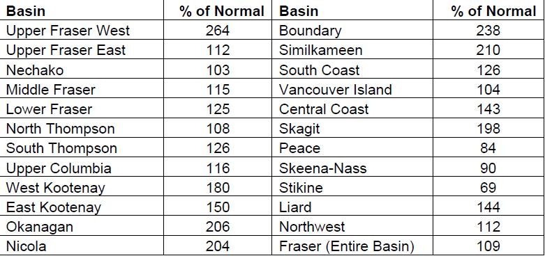
Snow basin indices for May 1st 2018 range from a low of 69% of normal in the Stikine to a high of 264% in Upper Fraser West (Table 1 and Figure 1). Overall, the province has well above normal snow pack for May 1st. The average of all snow measurements across the province is 168% of normal, increasing significantly from 127% of normal on April 1st. Of the 222 snow measurements taken for the May 1st survey period, 60 locations exceeded their previously recorded maximum May 1st values. High snow basin indices reflect actual increases in snow water amounts over the past months in many locations. However, it is important to note that, particularly in areas which typically experience significant melt between April and May, extremely high basin index values can be reflecting the greater
difference between current conditions and what would normally be a melting snow pack. Therefore, snow basin index values are enhanced when there is a delay in the melt season.
Extremely high snow packs (>150%) are present in the Upper Fraser West, Nicola, Okanagan, Similkameen, Boundary, Skagit, West Kootenay, East Kootenay. The May 1st snow index for the Okanagan is 206% of normal, which is the highest observed snow pack dating back to 1980. While many snow basin index values increased by 50% or more since April 1st, the amount of increase in snow water content over this period has been more in the 5-16% range for most basins. In the Liard basin, the high basin value represents a delay in the melt season rather than high seasonal snowpack.