The February 1st snow survey is now complete. Data from 86 snow courses and 69 automated snow weather stations around the province, collected by the Ministry of Environment Snow Survey Program and partners, and climate data from Environment and January weather patterns affecting British Columbia were mixed. Generally, the month featured above-normal (+0.5 to 2.0°C) temperatures across most of the province, with areas of warmer temperatures in the Kootenays.
The first half of the month was mild with light precipitation and subdued snow accumulation. Several significant storm events affected the province in the second half of January, especially for the southern half of the province. An atmospheric river in late January created flood conditions on Vancouver Island. January precipitation totals were well above normal for the southern half of BC, while the Northwest and North Coast regions were below normal.
Snowpack
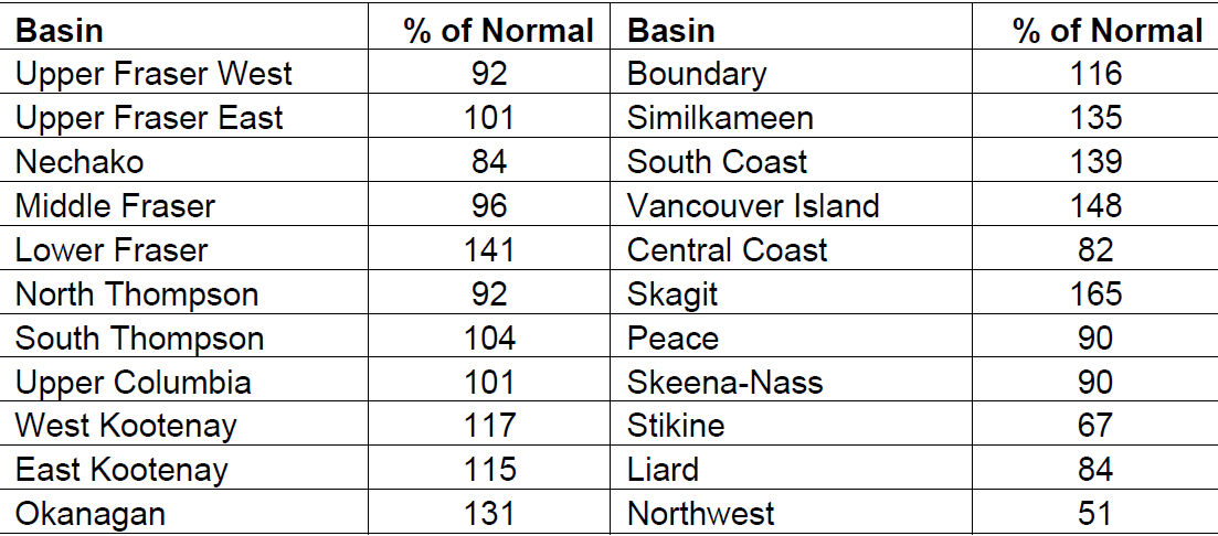
Snow basin indices for February 1st 2018 range from a low of 51% of normal in the Northwest to a high of 165% in the Skagit (Table 1 and Figure 1). Overall, the province has a slightly-above normal snow pack for February 1st, with the average of all snow measurements across the province at 108%, increasing significantly from 96% of normal on January 1st. Well-below normal snowpack is present in the Stikine (67%) and Northwest (51%).
Well-above normal snow pack (>130%) is present in the Okanagan, Similkameen, Lower Fraser, South Coast, Skagit and Vancouver Island. Above normal snow pack (110-120%) is present in the East Kootenay, West Kootenay and Boundary regions. Near normal snowpacks (80-110%) are present throughout the rest of the province. The Fraser River snow index as an entire watershed is 101% of normal.
The persistent unsettled weather in late-January for the southern half of the province increased the snow pack considerably. The most dramatic increases occurred for south coastal regions. Vancouver Island increased from 96% on January 1st to 148% of normal, the South Coast from 106% to 139% of normal, and the Lower Fraser from to 99% to 141% of normal.
Outlook
La Niña conditions are present, with negative sea surface temperature anomalies acrossmuch of the eastern and central sections of the equatorial Pacific Ocean. Over the past month sea surface temperature anomalies have steeply declined in the northern Pacific Ocean off the coast of the BC, with cooler than normal temperatures now dominant. The Climate Prediction Centre (CPC) at the U.S. National Weather Service/NOAA is forecasting a high likelihood of La Niña persisting through the winter, with a transition to ENSO-neutral conditions expected during the spring. Typically, La Niña is linked to cooler winters across
British Columbia and snowpacks tend to be higher than normal. Over the past 6 weeks weather patterns have aligned with typical La Niña weather, bringing significant growth to the provincial snow pack.
Seasonal forecasts (February to April) from Environment and Climate Change Canada are indicating an increased likelihood of normal temperatures across western and southern British Columbia and below normal temperatures in south-east and northern BC. Short-to medium term forecasts are suggesting near normal temperatures through February. A storm event is currently impacting the Interior, Central Coast and North Coast, with significant snow accumulation occurring in many areas. By early February, nearly two-thirds of the annual BC snowpack has typically accumulated. High snow packs in the South Interior, including the Skagit, Similkameen and Okanagan, may be an early indication of increased seasonal flood risk for the upcoming freshet season. In coastal areas, including Vancouver Island and South Coast flooding on local river systems generally occurs in the fall-winter period, and spring flood risk is minimal. In the Lower
Fraser, high snow pack can contribute to increased spring flood risk on the Lillooet River and tributaries, and increased seasonal runoff in the spring can also contribute higher localinflows to the lower reaches of the Fraser River.
Seasonal volume runoff forecasts (see below) are near-normal (85-105%) for the Upper Fraser, Middle Fraser, Thompson and Skeena/Bulkley basins, and well above-normal (>120%) for areas of the South Interior, including the Okanagan, Similkameen and Nicola. Similarly the snowmelt component of seasonal runoff on Vancouver Island, South CoastLower Fraser and Skagit is expected to be higher than normal given the high snow pack in those regions. Well below normal snow packs in the North-west and Stikine are an early indication of the potential for below normal seasonal runoff.