The January 1st snow survey is now complete. Data from 76 snow courses and 64 automated snow weather stations around the province, collected by the Ministry of Environment Snow Survey Program and partners, and climate data from Environment and Climate Change Canada have been used to form the basis of the following report1.
Weather
Fall and early-winter weather had been variable across the province. October featured near normal (-0.5 to 0.5°C) temperatures across most of the province, with areas of warmer temperatures in north-east BC. Wet conditions were prevalent in northern, central and eastern BC. During October an extreme rainfall event occurred on Vancouver Island, Central Coast and North Coast and led to flooding in some areas. November was wet across most of the province, particularly in south-west and north-east BC. A series of atmospheric river events impacted south-west BC with heavy rain. Temperatures were generally near normal for southern BC, with warmer minimum temperatures in south-east BC. In northern BC temperatures were colder than normal, with most areas experiencing monthly average temperatures that were 2-5°C below normal. Weather patterns flipped in December, ushering in the dominance of Arctic air across British Columbia. Temperature departures were variable across the province, with most areas experiencing slightly below normal temperatures. High pressure throughout the month deflected major weather systems away from the province, and led to drier than normal conditions. Weather transitioned into more westerly flow with increasing precipitation towards the end of the month.
Snowpack
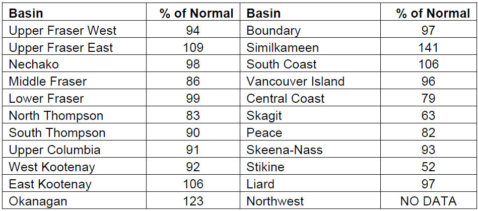
Snow basin indices for January 1st 2018 range from a low of 52% of normal in the Stikine to a high of 141% in the Similkameen (Table 1 and Figure 1). Generally the province has nearnormal snow pack for January 1st, with the average of all snow measurements across the province at 96%. Well below-normal snowpack (<65%) is present in the Stikine. Above normal snow pack is present in the Okanagan and Similkameen. Near-normal snowpacks
(80-110%) are present throughout the rest of the province.
Two key weather factors have been driving the seasonal snowpack development so far this year. First, cool and wet weather in November led to rapid development of the early-season snow pack. By late-November snow pack at ASWS was 120-125% of average across the province. The second key factor was the dominance of dry, Arctic air through December. While temperatures were low, precipitation was limited, and there was very limited
accumulation of snow throughout the majority of the month. Towards the end of December westerly flow patterns brought back snow accumulation, including low elevation snow in southern BC.