 Okanagan Snowpack – highest in province – holding at 131% – April 1st
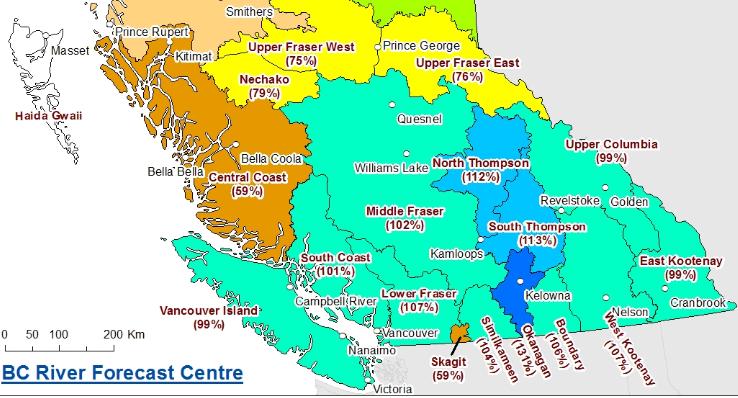
Snowpack
Despite the warmer weather, wet conditions led to seasonal snow pack growth across most of the province through March. In Northern BC, many basins experienced a drop in basin index values since last month, and in the Okanagan and Boundary, basin index values increased. In general, snow basin indices are near normal (80-120%) across the province, with a provincial average of 91%.
Below normal indices (65-80%) are present in the Upper Fraser West, Upper Fraser East, Nechako, and Skeena-Nass, and well below normal (<65%) in the Central Coast, Stikine, North-West, Liard and Skagit.
Well above normal snow packs (>120%) are present in the Okanagan. Lower snowpack in the Upper Fraser is offset by slightly higher than normal snow packs in the Thompson River basin, and the overall Fraser River basin index is 96%.
Due to warm weather throughout the winter, low to mid elevation snow packs across the province are greatly diminished this season. While the provincial average for all April 1st surveys is 91% of normal, the average for sites below 1200 m elevation is 62% of normal, and just 44% of normal for sites below 1000m.
Warm weather towards the end of March and in early April has led to the onset of the melt season across the province. All of the provincial automated snow weather stations have recorded melt over the past week, as well as a number of manual surveys which experienced a loss of snow water equivalent between the March 1st and April 1st surveys. The transition from snow accumulation to snow melt is two to three weeks earlier than usual this season.
Weather
Temperatures across British Columbia continued to be well above normal through the month of March, with daily temperatures being 1-3˚C above normal through southern BC, and 2‑4˚C above normal through the Kootenays, Central, and Northern BC. These warm temperatures have persisted throughout the 2015-16 winter.
March was generally a wet month, with a few heavier storm cycles mixed with drier and unsettled periods with lighter precipitation. A high pressure system with dry and very warm weather dominated the end of the month. Precipitation in March was above normal across most of the province, with typical precipitation amounts in the range of 130-200%. In the Central Interior, precipitation was closer to normal, and the Central Coast, North Coast and North-West were drier than normal.