Snowpack
Wet weather through February led to increased snow packs across the province, and most
regions of the province experienced an upswing of 5% to 10% in snow basin index values
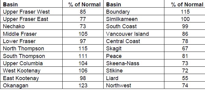
since last month. Snow basin indices range from a low of 55% in the Liard to a high of
123% in the Okanagan (Table 1). In general, most of the province has near normal or
slightly below normal (80-110%) snow packs for March 1st, 2016, with a provincial average
of 93% from all survey locations. A south to north gradient still exists across the province,
however very low snow packs observed earlier in the season in northern BC have generally
moderated. Below normal snow packs (65-80%) are present in the Upper Fraser East,
Nechako, Central Coast, Skagit, Skeena-Nass, Stikine, and North-west, and well below
normal (<65%) in the Liard. Above normal snow pack (>110%) is present in the Okanagan
and Boundary.
Weather
Temperatures across British Columbia continued to be well above normal through the month
of February, with daily temperatures being 1-3°C above normal through southern BC, and
3-5°C above normal through the Kootenays, central, and northern BC. These warm
temperatures have persisted throughout the 2015-16 winter (December, January,
February), with temperature departures being 1-4°C above normal across the province over
the three month period.
February was generally a wet month, with a few heavier storm cycles mixed with drier and
unsettled periods with lighter precipitation. Precipitation was above normal, with typical
precipitation amounts in the range of 130-200% of normal across most of the province.