Current Regulations: There is currently no Motor Vehicle Prohibition Regulation within the Oliver Mountain Goal 2 Area*, within Management Unit 8-01.
*The Goal 2 area of Oliver Mountain is a proposed protected area following the recommendations of the Okanagan Shuswap Land and Resource Management Plan (2001). To date, the Goal 2 area remains unprotected.
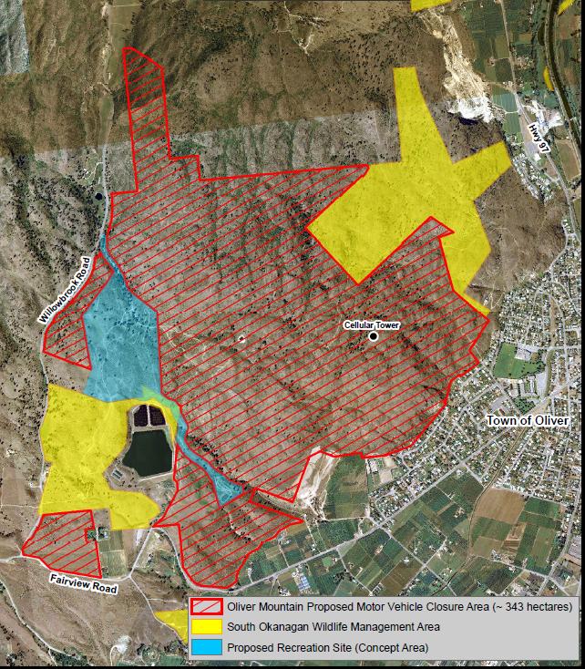
Proposed Regulations: This proposal seeks to contain Off Road Vehicles (ORV) use to two existing high use areas (and a connector corridor) within the Oliver Mountain Goal 2 area and to invoke a motorized closure for the balance of the Goal 2 area. This regulation would be implemented as a 5 year trial to monitor compliance of ORV users, and to monitor the grassland and antelope brush community rejuvenation within the closure area. This proposed regulation would not apply to commercial activities other than hunting.
Rationale:
· Oliver Mountain (~356 ha west of Oliver) has significant Off Road Vehicle (ORV) use as well as sensitive natural features.
· In the Goal 2 area, ORV use is degrading the environmental value recognized by the Okanagan Shuswap Land and Resource Management Plan (OSLRMP), and is threatening globally imperiled antelope-brush plant communities and the established Wildlife Habitat Areas (WHAs).
· Efforts to manage ORV use have been ineffective due to limited regulatory tools available.
· 17 federal and 14 provincially listed species and ecosystems at risk, including 2 globally imperiled plant communities have been identified on the site.
· There are 7 Forest and Range Practices Act (FRPA) WHAs established within the area.
· Goal 2 protected areas were established to protect the special natural, cultural heritage and recreational features of the province, including rare and endangered species and critical habitats, and outstanding outdoor recreational features such as trails.
· Acceptance by motorized users of the Goal 2 area of Oliver Mountain becoming a designated protected area was contingent upon finding a nearby designated area for ORV use; however, prospective sites identified to date have not been deemed feasible.
· In fall 2013 discussions took place between Forest, Lands and Natural Resource Operations (FLNRO) and MOE (Ministry of Environment) Executive and staff, rider clubs and local conservation organizations regarding ORV impacts at Oliver Mtn.
· In March 2015, open house sessions in Oliver and Osoyoos were held to provide information about environmental values and ORV best practices.
· An advisory group of stakeholders met in summer 2015 to provide input on proposed management options, including establishing closed areas and alternate ORV use areas
Open Letter
We wanted to provide an update on the Oliver Mountain Off Road Vehicle (ORV) Management Strategy. As you recall we developed an Options paper last fall based on the planning process to explore various options to protect sensitive resource values in the Oliver Mountain Area, while considering recreational user’s needs.
Since that time the Ministry of Forests, Lands and Resource Operations statutory decision makers in liaison with BC Parks have selected a preferred option and we have been working with Osoyoos Indian Band to confirm support and process for how to move forward together.
Together with Osoyoos Indian Band the decision for moving forward is to contain the ORV use to the upper and the lower track areas contiguously with linear trail connection (i.e. the upper node and lower node) within the Oliver Mountain Goal 2 area and to invoke a motorized closure for the balance of the area. It was agreed that the best strategy to address competing demands on Oliver Mountain is to promote a collaborative approach to achieving conservation objectives.
The plan will be to move forward with this option on a 5 year trial basis so that we can monitor both behaviour and compliance of the ORV users, and to conduct Antelope brush community restoration in the motorized closure area. As part of this plan there will need to be a strategy developed to monitor progress as well as a plan for signage and engineering needs to contain the motorized use to the designated area (note this likely will be some control structures in strategic locations to restrict entry of ORV use into the motorized closure area).
The proposed motorized closure regulation change would not apply to commercial activities other than hunting. The intent is that existing tenure holders such as range or commercial Land Act tenure holders will be able to access their tenures by motorized means within the proposed closure area, though we will encourage non-motorized access to those tenures where feasible.
Please note that this will be a recreation site where motorized use will be authorized along designated routes. What this means is that within the proposed recreation polygon a portion of the area will be designated for motorized use and a portion of the area will be designated for non-motorized use. The exact boundaries for the designated motorized use routes and non-motorized areas are to be determined in the next few months. There will be consultation on the proposed recreation polygon in the next few months.
Amy Tipler Land and Resource Management Specialist
Ministry of Forests, Lands and Natural Resource Operations
** letter edited for clarity