 1. License of Occupation – KVR Area C
THAT the Board of Directors make application to the Province of British Columbia for a License of Occupation over 4 sections of the former Kettle Valley Right of way legally described as: Plan KAP423A DL 648S SDYD Portion PCL B3 D E F, Except Plan EPP23666, C/REF 03554.015 FOR GAS PIPELINE R/W SEE R/W 337997 FOR POWERLINE. Plan KAP429A DL 28S SDYD SEE 714-01133.901 FOR LEASE PORTION. Lot 1A Plan KAP1729 DL 2450S SDYD Lot 1B Plan KAP1729 DL 2450S SDYD Except Plan KAP74281, LICENSE NO 339180 FOR AGRICULTURAL PURPOSES. AND THAT the Board of Directors make application to the Ministry of Transportation and Infrastructure (MoTI) for a Permit to Construct within a section of MoTI Right-of-Way; AND THAT the Board of Directors authorize staff to enter into discussions with Osoyoos Indian Band (OIB) to negotiate an agreement to use that section of rail trail that crosses OIB Lands; AND THAT the Chair and Chief Administrative Officer be authorized to execute the License of Occupation with the Province of British Columbia if successful.
History: The 2011 Regional Trails Master Plan (RTMP) identified acquiring tenure over the former Kettle Valley Railway as a priority to establish a regional trail network within the RDOS. As indicated in the Master Plan, trails offer invaluable opportunities for tourism, social, health and natural benefits. The Kettle Valley Trail in particular is of vital importance to the people of Canada, in particular the residents of the RDOS, who wish to see continued free and open access of our public corridors.
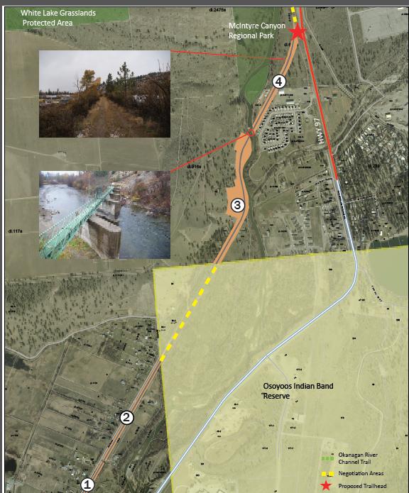
Analysis: The KVR right-of-way is not a continuous corridor along this section of the KVR in Area C and a number of jurisdictional negotiations and infrastructure requirements are needed to connect the corridor. Negotiations with the Ministry of Transportation and Infrastructure will be required to construct within the right-of-way of the newly twined section of Highway 97 in addition to discussions with Osoyoos Indian Band for the approximately 550m portion that crosses OIB lands.
A number of infrastructure requirements will also be required make the KVR a continuous rail trail: • An opportunity exists with existing infrastructure within the Okanagan River for potential retrofitting for a pedestrian bridge. • Following our trail standards, staff would pursue resurfacing as local funds or grants become available. Based on comparable re-surfacing projects, staff estimates the cost to resurface at approximately $25,000/km of trail. • The southern point of the proposed application area will connect with the Oliver River Channel. Should the board decide to pursue tenure for the proposed application area, RDOS staff will undergo a public consultation process for community/institutional stakeholders during the application period.
Once tenure is acquired, RDOS Regional Trails program will continue to work with residents as well as provide operational improvements and maintenance of this section of trail.
Lindsay Bourque Rural Projects Coordinator