 Item #1 – Endorsed by Area Planning Commission and returned to RDOS Board
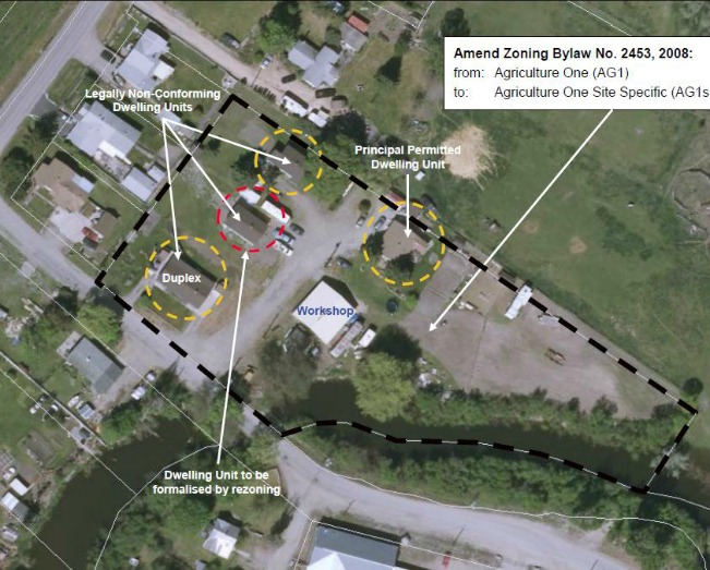
Purpose: To formalise the existence of a legally non-conforming single detached dwelling unit.
Owners: Byron and Aina Stetsko Agent: Urban Connections Folio: C-05796.000
Location – (east of Sawmill Rd next to ox bow to north of Thorpe Rd
OCP: Agriculture (AG) Zoning: Agriculture One (AG1) Proposed Zoning: AG1 Site Specific (AG1s)
Proposed Development:
This proposal is seeking to amend the zoning of the subject property in order to formalize the existence of a legally non-conforming single detached dwelling unit. It is proposed to amend the density provisions of the AG1 Zone in order to allow for an accessory dwelling unit on a parcel less than 3.5 hectares (ha) in area.
The applicant has stated that this “will allow all of the existing dwellings to remain on the subject property and allow the owners to make the necessary repairs to the homes to keep the homes in a state of good repair to allow the homes to continue to be used as affordable housing for persons wishing to reside in rural Oliver …”
Site Context:
The subject property is approximately 9,700 m2 ha in area and is situated on the north side of Thorp Road and is adjoined by an oxbow associated with the Okanagan River along part of its southern side boundary.
Development of the property is seen to be comprised of an existing duplex, three single detached dwellings, a chicken coop, well and pump house and a workshop/storage structure. The applicant has indicated that the dwellings have been on the property since the 1950s, while the chicken coop and workshop are more recent additions.
Background:
A Building Permit was previously issued in 1977 for an addition to the dwelling located on the east side of the access driveway. Accordingly, the Regional District considers this unit to represent the principle single detached dwelling unit permitted under the zoning, with all other dwelling units to be legally non-conforming (see Attachment No. 2).
On March 3, 2013, a Stop Work Notice was posted for “structural renovations & additions to a dwelling … without a building permit” on one of the legally non-conforming dwellings.
In May of 2013, an appeal to the BoV was submitted to the Regional District in order to allow for the renovation and additions that were the subject of the Stop Work Notice to be completed. The BoV refused this appeal on June 25, 2013.
The Advisory Planning Commission (APC) is also asked to be aware that the number of dwellings currently found on the subject property may not be characteristic of an agricultural operation, and that a Low Density Residential zoning may seem more suitable (as opposed to an AG1s zoning), Section 8.4.1.1 of the OCP “directs that any new Low Density Residential Designation shall [emphasis added] be connected to a community water system and a community sewer system”.
At such time that a community water system and a community sewer system become available on Sawmill Road, Administration considers that it may be appropriate to review the zoning of the subject parcel as well as adjacent properties — bearing in mind that the area between the Town boundary and the subject property is within the ALR.
Administrative Recommendation: THAT the APC recommends to the RDOS Board that the subject development application be approved. AGREED TO
***
Item #2 – Not endorsed. No motions carried – returned to RDOS Board
Subdivision within the ALR
Purpose: To facilitate a boundary adjustment that would create new parcels of approximately 1.0 ha & 9.16 ha.
Owner: Pamela Luckhurst
Civic: 607 Ponderosa Road & 700 Pallay Road Zone: Agriculture One (AG1)
Proposed Development:
An application has been lodged with the Agricultural Land Commission (ALC) to permit a subdivision to occur within the ALR.
Specifically, the applicant is seeking the Commission’s approval to undertake a boundary adjustment in which an area of approximately 4.02 hectares of land would be subdivided from the property at 607 Ponderosa Road, thereby leaving a parcel area of approximately 1.0 ha (see Attachment No. 2). It is then proposed to consolidate this land into the adjoining parcel at 700 Pallay Road, thereby creating a new, larger parcel of approximately 9.16 ha in area.
The applicant has indicated that “the proposed residential component of the sub-division … is steep hill side going down to the irrigation canal R/W, the balance of the 2 properties to be combined approx. 10 ha., will make for a larger and more versatile agricultural piece of land.”
Site Context:
The subject properties are under the same ownership and are situated to the south-east of the intersection of Pallay Road and Ponderosa Road and are located approximately 7.5 km south-west of the Town of Oliver (immediately to the north of the location of the 2010 Testalinden Creek landslide).
The property at 607 Ponderosa Road is approximately 5.02 ha in area, has been assessed as “farm” and “residential” by BC Assessment, is comprised of a single detached dwelling, shop and shed with the remainder of the parcel under agricultural production (i.e. vineyard).
The property at 700 Pally Road is approximately 5.14 ha in area, has been assessed as “farm” and “residential” by BC Assessment, is comprised of a single detached dwelling and “metal storage farm building” with the remainder of the parcel under agricultural production (i.e. vineyard).
Surrounding land use patterns are predominantly characterised by agriculturally productive land, undeveloped and environmentally sensitive Crown land further to the west, and a small residential cluster of 11 parcels on the north side of Ponderosa Road.
Background:
Under the Electoral Area ‘C’ Zoning Bylaw No. 2453, 2008, the subject properties are both zoned Agriculture One (AG1), which establishes a minimum parcel size requirement of 4.0 ha.
While certain exemptions for boundary adjustments are provided at Section 5.2 of the Zoning Bylaw, this application is not seen to qualify as it is proposing to create a parcel size less than that allowed by the zoning (i.e. 1.0 ha).
At its meeting of October 4, 2013, the Regional District Board resolved to defer making a decision on this particular application and directed that the proposal be considered by the Electoral Area ‘C’ Advisory Planning Commission (APC).
Analysis:
The proposal seeks to create a rural-residential sized parcel (i.e. 1.0 ha in area) that will have limited agricultural potential due its reduced size and level of development, and which may result in an incompatible land use being introduced into an Agricultural designation.
The fragmentation of viable farmland is generally not supported, nor is the creation of ad hoc / spot residential parcels within active farming areas. While individually, such a parcel may seem harmless, incrementally these types of parcels could erode the area’s existing rural and agricultural character.
Conversely, it is recognised that the proposal seeks to increase the land area associated with the adjacent parcel from approximately 5 ha to 9.16 ha, and that this is being promoted as resulting in a more efficient use of agricultural land — which is supported by the OCP.
It is also noted that the introduction of a 1.0 ha rural residential sized parcel is not inconsistent with the character of the area given the previous development of similarly sized residential lots on Ponderosa Road. However, it is also noted that the subdivision of these residential lots occurred in the mid-1970s and are not reflective of current land use strategies as contained within the OCP or Regional Growth Strategy (which seeks to forestall the conversion of agricultural lands to residential uses).
Administrative Recommendation:
THAT the RDOS Board “authorise” the application for subdivision at 607 Ponderosa Road and 700 Pallay Road, Electoral Area ‘C’, to proceed to the Agricultural Land Commission. NOT ENDORSED